Madrid has a substantial amount of green space for a European capital, spread across a handful of very large parks rather than evenly distributed through the built city. The Madrid City Council’s own environmental reports put roughly a fifth of the municipal area under some form of green cover, though the exact figure moves between reports and should be checked on the council’s site (madrid.es) rather than treated as fixed. The bulk of it sits at the western and eastern edges of the centre, with smaller gardens threaded through the older districts in between.
How much of Madrid is actually green space?
There is no single, permanently fixed percentage — municipal land-use surveys are revised periodically, and different reports count different categories of land (parks, street trees, protected woodland at the city’s edge). What is consistent across those surveys is that Madrid ranks among the greener large European capitals, largely because of two enormous parks — Casa de Campo and Parque del Retiro — that together account for a disproportionate share of the total.
That concentration matters practically. It means green space in Madrid is not something a resident stumbles into on every corner of every district; it is something reached deliberately, usually by metro or on foot from a handful of access points, a pattern covered in more detail on the Madrid Practical hub.
Where is the city’s biggest park, and how large is it?
Casa de Campo, on the western bank of the Manzanares in the Moncloa-Aravaca district, is Madrid’s largest single green space by a wide margin. It covers roughly 1,700 hectares — several times the area of Parque del Retiro — and the Madrid City Council describes it as one of the largest urban parks in Europe. It was formerly a royal hunting estate before being opened to the public in the twentieth century, and it now contains the city zoo, an amusement park, a lake, and a large area of open woodland and scrubland that is far less manicured than the parks closer to the centre.
Because of its size, Casa de Campo functions less like a single park and more like a district-sized landscape, with a cable car (the Teleférico) linking it to Parque del Oeste on the opposite bank. Full detail on its history, size and how it compares to other large urban parks is covered on the dedicated Casa de Campo page.
How does Parque del Retiro compare?
Parque del Retiro, on the eastern edge of the historic centre, covers around 125 hectares — far smaller than Casa de Campo but far more central and far more formally landscaped. It began as a royal garden attached to the Buen Retiro Palace in the seventeenth century and was opened fully to the public in the nineteenth. It contains the Palacio de Cristal, a large ornamental lake, formal rose gardens, and the Ángel Caído fountain, among other features detailed on the site’s full guide to Retiro.
Retiro’s location — a short walk from the Prado and the Paseo del Prado museums — makes it the green space most visitors actually reach, while Casa de Campo, being larger but less central, is used more by residents than by anyone on a short trip.
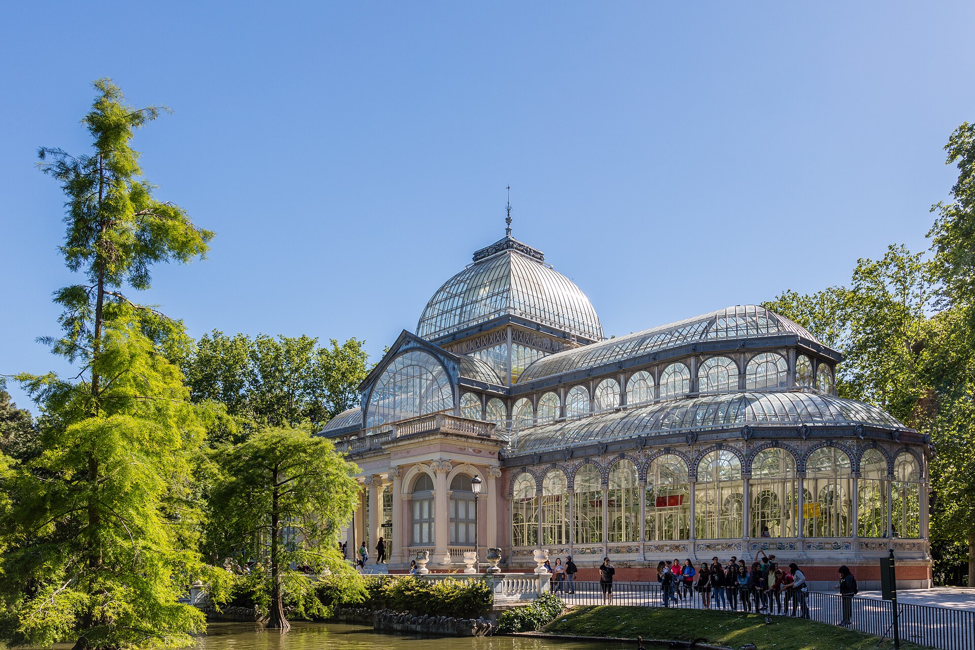

Where are Madrid’s other major parks?
Beyond the two largest, the city has a scattering of significant parks that a map does more to explain than a list:
- Parque del Oeste — Moncloa-Aravaca, a hillside park descending toward the river, home to the Templo de Debod.
- Madrid Río — a linear park running along the Manzanares through Arganzuela, built after the M-30 ring road was buried underground; covered in full on the Madrid Río history page.
- Quinta de los Molinos — in the eastern district of Ciudad Lineal, known for its almond trees and a short, well-documented blossom season; detail is on the Quinta de los Molinos page.
- Parque Juan Carlos I — a large, more modern park in the northeast, near the IFEMA convention centre.
- Dehesa de la Villa — a wooded park in the north of the city, closer to open scrubland than formal garden.
The pattern across all of these is the same: green space in Madrid tends to sit at district edges — river banks, old royal estates, former agricultural land — rather than being carved evenly through dense residential blocks. The districts and barrios explainer sets out how the city’s administrative geography maps onto this.
What about the smaller royal and botanical gardens?
Not every significant green space in Madrid is large. Two of the most historically important are compact and formal:
- Campo del Moro — the garden behind the Royal Palace, roughly 20 hectares, laid out in a nineteenth-century romantic-landscape style. It is covered on the Campo del Moro page.
- Real Jardín Botánico — adjoining the Prado, a formal botanical garden run under Spain’s national research council (CSIC), with a plant collection organised by taxonomy rather than left as open parkland. Detail is on the Real Jardín Botánico page.
These are worth distinguishing from the large public parks: both charge admission or restrict access at points, and both function as historical or scientific institutions as much as recreational space.
Is there a large forest at the edge of the city?
Yes. Monte de El Pardo, northwest of the city and largely within Madrid’s municipal boundary, is a protected estate of Mediterranean forest covering many thousands of hectares — several times the size of Casa de Campo. It has historically functioned as a royal hunting ground and remains under restricted public access in parts, managed jointly by Patrimonio Nacional and Spanish environmental authorities. It does not function as a public park in the way Retiro or Casa de Campo do, but it explains why the city’s northwestern edge reads as forest rather than suburb on any satellite map.
How close is the Sierra de Guadarrama?
Beyond the municipal boundary, the mountain range that shapes Madrid’s weather and its weekend habits — the Sierra de Guadarrama — lies within a manageable distance of the city by train or road, and part of it is protected as a national park. How close it actually is, and what the range consists of, is set out on the dedicated Sierra de Guadarrama page. It is not part of Madrid’s green space in an administrative sense, but for residents it functions as the city’s largest and closest natural escape.
How do residents actually use this green space?
The scale and placement of Madrid’s parks shapes daily life differently depending on where someone lives. A resident of Moncloa-Aravaca or Carabanchel has Casa de Campo effectively on their doorstep; a resident of Salamanca or Retiro district is closer to the park of the same name; someone in the south of the city relies more on Madrid Río and smaller district parks. The Living in Madrid hub covers how this geography plays into everyday routines, from weekend habits to where families with children tend to gather.
Getting to any of these parks is straightforward by metro or bus rather than requiring a car — Casa de Campo and Parque del Oeste both have direct metro access, and Madrid Río runs alongside several stations along the river. Details on how the transit network is structured are covered in the Getting Around archive.
What is the simplest way to think about Madrid’s green space?
Picture two large green anchors — Casa de Campo to the west, Retiro toward the centre-east — connected loosely by the river corridor of Madrid Río, with smaller historic gardens (Campo del Moro, the Real Jardín Botánico) sitting close to the Royal Palace and Prado respectively, and a scatter of district parks filling in the rest. Further out, Monte de El Pardo and the Sierra de Guadarrama extend that green belt well beyond the city limits. For a fuller picture of how parks fit alongside the rest of what the city offers, the Parks & Outdoors archive and the Madrid Guide hub are the two places to start.
Access Madrid is an independent guide written from published, checkable sources. We have not visited the places described here and we do not publish personal recommendations or invented ‘local favourites’ — where something is singled out as notable, we say who says so. Opening times, fares, closures and prices change at short notice, so treat everything here as a starting point and confirm with the museum, operator or venue directly before building a day around it. We give no advice on visas, insurance, health or safety; use your own government’s official guidance for those.
Featured image: Photo by Diego Delso, source, CC BY-SA 4.0
