Madrid Río is a six-kilometre park that runs along both banks of the Manzanares river, from the Puente de los Franceses in the north down past Puente de Toledo. Before it existed, this stretch of riverbank carried the M-30 ring road at surface level, cutting the river off from the city it ran through. The park sits on top of the tunnels that now carry that traffic underground.
What is Madrid Río, exactly?
Madrid Río is a linear public park built by the Ayuntamiento de Madrid (Madrid City Council) between 2005 and 2011, following the burial of the M-30’s riverside section into a system of tunnels. The park covers roughly 1.2 million square metres of former road land, according to the city council’s own project documentation, and stitches together green space, pedestrian and cycle routes, playgrounds, sports courts and a series of bridges old and new along both sides of the Manzanares.
It was designed by the Dutch landscape firm West 8 together with the Madrid practice Burgos & Garrido, working as part of the joint team MRIO Arquitectos, winners of the international competition the city council ran for the project. That authorship matters for understanding the park: it was conceived as a single continuous landscape, not a string of separate parks, which is why walking or cycling its length feels uninterrupted even as it passes under half a dozen historic bridges.
What was there before the park?
Before 2007, the riverbanks here were occupied by the M-30, Madrid’s inner ring road, running largely at grade or on elevated sections directly alongside the water. The Manzanares itself had been channelled and embanked for flood control over the twentieth century, and the road effectively sealed the river off from the neighbourhoods on either side — Arganzuela, Latina, Carabanchel and Moncloa-Aravaca all had a river running through them that residents could see but not easily reach.
Older maps and photographs held by Madrid’s own city history museum show a working river corridor before that: mills, market gardens, and a scatter of industrial uses along the banks well into the twentieth century, alongside the older stone bridges that still stand today, including the Puente de Segovia and the Puente de Toledo. The M-30’s construction in the second half of the century, and its later widening, progressively buried this working relationship between the city and its river under traffic infrastructure.
Why was the M-30 put underground?
The city council’s stated rationale, set out in its Madrid Río project materials, was to reclaim the riverbanks for public use while keeping the M-30’s traffic capacity intact by moving it into tunnels rather than removing it. The project rerouted the ring road into a series of bored and cut-and-cover tunnels running beneath the new park, in one of the largest urban infrastructure projects the city has undertaken.
This is worth being precise about: the M-30 was not closed or reduced. It continues to carry a significant share of Madrid’s ring-road traffic, now largely out of sight beneath the park. The through-traffic that used to run at street level along the river is what disappeared from view, not from the road network.
What can you actually find in Madrid Río today?
The park is organised as a continuous strip rather than a single site, and its features are spread along its length rather than concentrated at one entrance. Recurrent elements include:
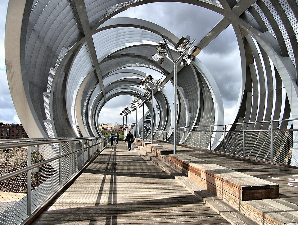
- A series of bridges spanning the river, from centuries-old stone crossings like the Puente de Segovia and Puente de Toledo to new pedestrian structures, including the Puente de Arganzuela footbridge designed by Dominique Perrault.
- The Salón de Pinos, a long pine-lined promenade running along one bank.
- An urban water feature commonly referred to as the Playa de Madrid Río, a shallow splash area rather than a beach in the coastal sense.
- Skate parks, climbing structures, and sports courts distributed along the route.
- Continuous cycling and walking paths that connect, at their northern end, toward the green belt around Casa de Campo.
For a sense of scale against the city’s other large green space, it’s worth reading how Casa de Campo’s size compares, since the two areas sit close enough to be walked between.

What is Matadero Madrid, and how does it fit in?
Matadero Madrid is a cultural centre occupying the former municipal slaughterhouse and livestock market, a large complex of early-twentieth-century industrial buildings that sits within the southern stretch of Madrid Río, in the Arganzuela district. The council converted the disused site into exhibition, performance and workshop space in stages from the mid-2000s onward, and it now runs as an independent public cultural institution under city council ownership.
Its presence inside the park is not incidental. The Matadero’s brick sheds, cattle pens and rail sidings were built precisely because this stretch of riverbank was, for most of the twentieth century, an industrial and infrastructural zone rather than a public one — the same character that the M-30 later reinforced. Full detail on the site’s programme and buildings sits outside the scope of this article, but the institution’s own site is the reliable source for current exhibitions and opening arrangements.
Which districts does Madrid Río run through?
The park runs along the boundary of several of Madrid’s administrative districts rather than sitting inside just one. Arganzuela forms its eastern, more central bank; Latina and Carabanchel sit along the western side further south; Moncloa-Aravaca borders its northern stretch near Casa de Campo. Understanding how Madrid’s districts and barrios are structured helps make sense of why a single park can be described as belonging to several neighbourhoods at once rather than one.
A dedicated look at how the park sits within its home district is covered in the piece on Arganzuela and Madrid Río, while the districts on the opposite bank are covered separately: see the explainers on Carabanchel and Moncloa-Aravaca.
How do you get to Madrid Río?
The park has metro stations along most of its length, including stops serving Príncipe Pío, Puerta del Ángel and Legazpi, among others, and several EMT bus routes cross it. Because it runs for six kilometres, the practical approach is to pick an access point close to whichever section is of interest — the Matadero end, the Puente del Rey end, or the Casa de Campo end — rather than trying to enter at a single gate. Details on how the wider transport network fits together are covered in the Getting Around archive, and the metro’s fare structure is explained separately in the guide to how Madrid’s metro fares work.
The park’s continuous cycle path also connects to Madrid’s bike-share network; how that system operates is set out in the explainer on BiciMAD.
Is Madrid Río a park for visitors or for residents?
Both, though it functions differently for each. For residents, it operates as functional green infrastructure: a running and cycling route, a place for weekend sport, and — for the districts it borders — the nearest large open space, in the way that Parque del Retiro serves the districts around the centre. For visitors, its interest lies less in any single monument than in what it demonstrates about Madrid’s recent urban planning: a major twentieth-century road reversed and replaced with public space, without removing the road itself.
It sits well outside the historic centre covered by routes like the walk through Madrid de los Austrias, and is not a stop on the standard first-visit itinerary. It is, instead, the kind of place that rewards a reader who already understands central Madrid and wants to see how the city has handled its own infrastructure — a subject explored more broadly in the Parks & Outdoors section and the Living in Madrid hub.
Access Madrid is an independent guide written from published, checkable sources. We have not visited the places described here and we do not publish personal recommendations or invented ‘local favourites’ — where something is singled out as notable, we say who says so. Opening times, fares, closures and prices change at short notice, so treat everything here as a starting point and confirm with the museum, operator or venue directly before building a day around it. We give no advice on visas, insurance, health or safety; use your own government’s official guidance for those.
Featured image: Photo by Jose Luis Cernadas Iglesias from Coruña, España, source, CC BY 2.0
