The Barrio de Salamanca is a 19th-century district east of Retiro park, built from the 1860s onward as a planned extension to a Madrid that had outgrown its old walls. It was laid out on a strict grid by private developers under a royal-authorised city plan, which is why its streets run straight and its blocks feel uniform.
What area does the Barrio de Salamanca actually cover?
It sits in Madrid’s Distrito de Salamanca, one of the city’s 21 administrative districts, bounded roughly by Calle de Alcalá to the south, the Castellana to the west, and Calle de María de Molina and the M-30 ring to the north and east. Retiro park forms its western edge along much of its length.
Inside that boundary the district is subdivided into named barrios — Recoletos, Goya, Fuente del Berro, Guindalera, Lista and Castellana — but “Barrio de Salamanca” in everyday speech usually means the grid closest to Retiro: Recoletos, Goya and Lista, the streets built earliest and most consistently.
Why is it called Salamanca?
The district takes its name from José de Salamanca y Mayol, Marqués de Salamanca, a 19th-century financier, railway promoter and politician who bought agricultural land east of the old city and financed its urbanisation from 1862 onward. City histories and the Ayuntamiento de Madrid’s own district material credit him as the project’s driving promoter, though he was one of several investors and the venture went through serious financial difficulty before the area was fully built out.
What was the Ensanche, and why did Madrid need one?
The Ensanche — literally “widening” or “extension” — was a national policy for regulated urban growth, applied to Madrid, Barcelona and other Spanish cities in the mid-19th century once their historic walls were demolished. It replaced organic, irregular medieval street patterns with planned grids designed for the population growth and public-health demands of an industrialising country.
Madrid’s old centre — the area now covered by La Latina, Malasaña and Lavapiés — was overcrowded and largely built before modern sanitation. Madrid’s city walls, the Cerca de Felipe IV, were pulled down in the 1860s, formally opening the land beyond them to development. An 1860 general plan for the Madrid Ensanche, associated with the engineer Carlos María de Castro, set out the wider framework of straight avenues and regular blocks that Salamanca’s developers then filled in on the ground.
Why is the grid so regular compared with the rest of Madrid?
Because it was designed on paper before a single building went up, rather than growing street by street over centuries. Castro’s Ensanche plan specified wide, straight streets crossing at right angles, standard block dimensions, and generous street widths intended to improve light, ventilation and traffic circulation — a direct response to the cramped, poorly ventilated centre.
Salamanca’s developers built to that logic with unusual consistency. Streets such as Serrano, Velázquez and Goya run in long, uninterrupted lines; blocks are close to uniform in depth; and buildings were originally conceived with rear courtyards for light and air, following contemporary hygienist thinking about how a city should function rather than how one had simply accumulated.

Why does the district still read as upper-class housing?
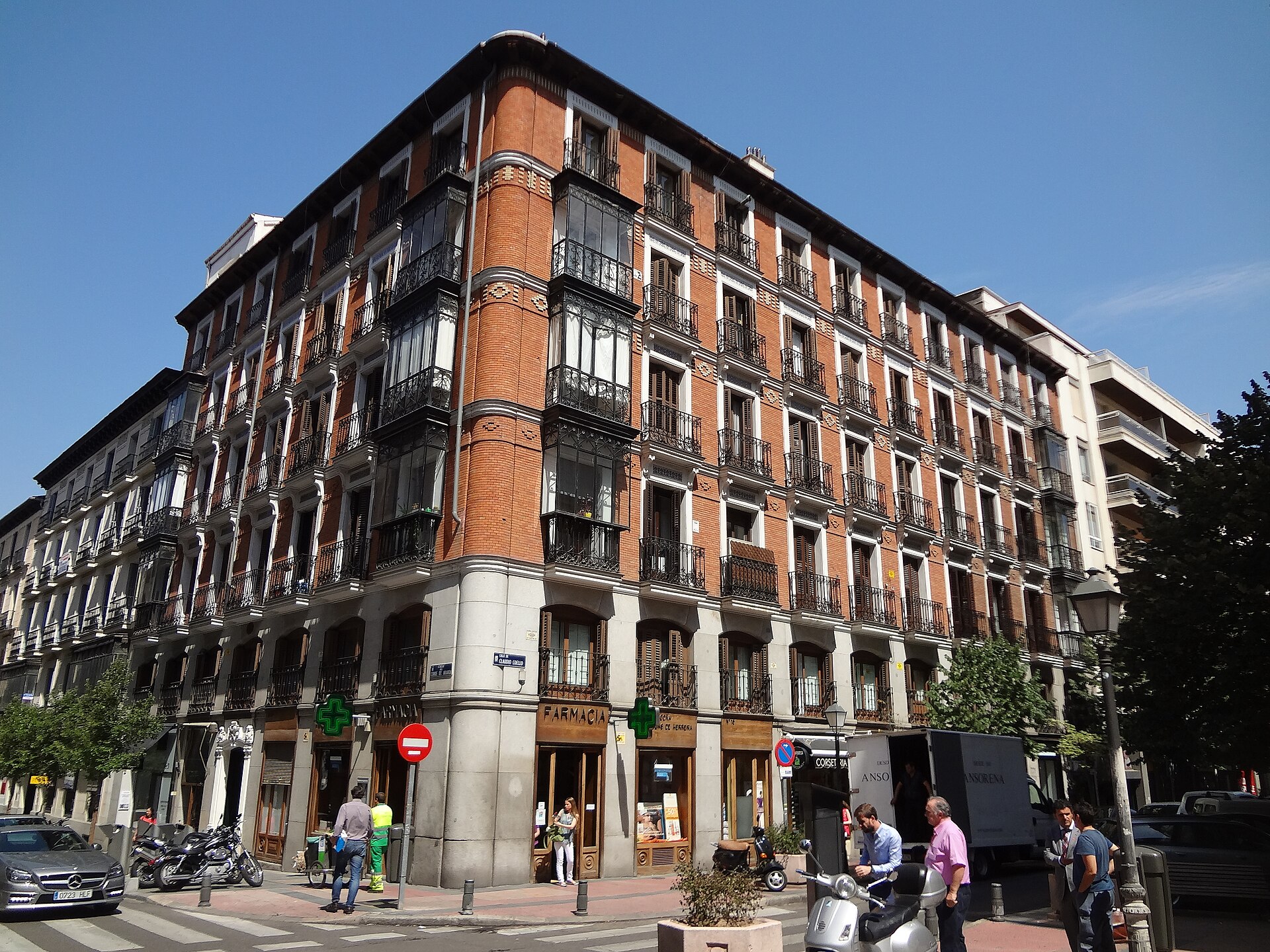
Because it was built as such from the outset, and city planning since has largely preserved that character. Salamanca’s original apartment blocks were aimed at Madrid’s growing professional and commercial classes — a market distinct from the aristocratic centre and from the working-class districts forming around the old walls in places like Lavapiés.
The building type is consistent: mid-rise blocks, generally four to six storeys, with decorated stone or stuccoed façades, wrought-iron balconies and, in the surviving originals, tall windows and moulded cornices. Many blocks combined ground-floor commercial premises with residential floors above, a mixed-use pattern that persists today in the district’s concentration of shops along Serrano and Ortega y Gasset.
Is the Barrio de Salamanca a shopping district too?
Yes. The so-called “Milla de Oro” (Golden Mile), roughly along Calle de Serrano and adjoining streets, is one of Madrid’s principal concentrations of international fashion and luxury retail, a role that developed through the 20th century as the district’s affluent residential character made it attractive to high-end shops. That commercial identity sits alongside, rather than replacing, its function as a dense residential neighbourhood.
What is there to see, beyond the streets themselves?
The district’s western edge runs along Retiro park, and its southern boundary meets Calle de Alcalá near the Puerta de Alcalá. Two house-museums inside or near its boundary give a direct sense of the period the Ensanche produced:
- The Museo Lázaro Galdiano, housed in the former mansion of the collector José Lázaro Galdiano on Calle de Serrano, holding his personal art and decorative-arts collection.
- The Museo Sorolla, the former home and studio of the painter Joaquín Sorolla, preserved as it was arranged in his lifetime.
Further north, the district borders the area around the Santiago Bernabéu stadium and the Cuatro Torres business towers along the Paseo de la Castellana, a reminder that Madrid’s 19th-century Ensanche eventually gave way, further north, to 20th- and 21st-century commercial building along the same axis.
How does Salamanca compare with Madrid’s older central districts?
The comparison is really between two different logics of city-making. Districts such as La Latina and Lavapiés grew informally over centuries inside the old walls, producing narrow, irregular streets and small, mixed-age buildings. Chueca and Malasaña sit at the edge of that older fabric, shaped by 18th- and 19th-century expansion but still within the historic street pattern.
Salamanca, by contrast, was planned wholesale under the Ensanche framework, with lot sizes, street widths and building lines fixed in advance. That single origin — one plan, one period, one intended market — is the main reason its architecture and street pattern read as more consistent than almost anywhere else in central Madrid.
Is Salamanca part of the areas visitors usually cover on foot?
It borders the areas most visitors concentrate on but is a distinct walking district in its own right, best treated as an extension from Retiro or Calle de Alcalá rather than a stop within the old centre. Its scale — long straight blocks rather than a compact tangle of lanes — makes it a different kind of walk from the historic centre, closer to a residential and retail district than a sightseeing route.
For the wider pattern of how Madrid’s districts differ in origin and character, the Neighbourhoods section covers the historic centre’s barrios individually. The district’s house-museums and nearby monuments are covered in more detail via the Museums & Galleries and Landmarks & Sights hubs.
What should a resident understand that a visitor might not?
For residents, Salamanca’s grid layout has practical consequences beyond appearance. Its regular blocks and consistent building depths mean flat sizes and layouts vary less than in the older centre, and its commercial ground floors concentrate specific trades — antiques, galleries, fashion — street by street, a pattern that has held since the original 19th-century plots were sold and built out individually within Castro’s overall scheme.
The district’s continued desirability, reflected in Madrid property and rental data published periodically by the Ayuntamiento de Madrid and by Spain’s national statistics institute (INE), traces directly back to its original design brief: broad, well-lit streets and a building type intended, from the start, for Madrid’s professional and commercial elite rather than for the aristocracy of the old centre or the working population beyond the former walls.
Access Madrid is an independent guide written from published, checkable sources. We have not visited the places described here and we do not publish personal recommendations or invented ‘local favourites’ — where something is singled out as notable, we say who says so. Opening times, fares, closures and prices change at short notice, so treat everything here as a starting point and confirm with the museum, operator or venue directly before building a day around it. We give no advice on visas, insurance, health or safety; use your own government’s official guidance for those.
Featured image: Photo by David Adam Kess, source, CC BY-SA 4.0
