Gran Vía is a 1.3-kilometre avenue driven through the dense centre of Madrid between 1910 and 1929, connecting Calle de Alcalá near Plaza de Cibeles to Plaza de España. It was not widened from an existing street — it was cut as a new route straight across an existing grid of narrow medieval and 16th-century lanes, and it demolished them to do it.
What is Gran Vía, exactly?
Gran Vía is Madrid’s principal early 20th-century avenue, running roughly north-west from the junction with Calle de Alcalá to Plaza de España. It is lined with buildings from the 1910s and 1920s in a mix of French Beaux-Arts, Viennese Secession and early Art Deco styles, and it remains one of the city’s main commercial and theatre streets.
The street sits within the central district of Madrid, threading between the older Barrio de las Letras and Sol area to its south and the Malasaña and Chueca neighbourhoods to its north. It is served by its own metro station, Gran Vía, on lines 1 and 5, run by Metro de Madrid.
When was Gran Vía built?
Construction began on 4 April 1910, when King Alfonso XIII laid the first stone at a ceremony marking the start of works. The avenue was not finished in one campaign: it was built in three successive sections and was not completed to its final layout at Plaza de España until 1929.
The idea long predated the digging. Proposals for a grand new artery through central Madrid circulated from the 1860s onward, part of a wider pattern of 19th-century European cities cutting broad boulevards through old quarters — Haussmann’s work in Paris is the most-cited comparison, though Madrid’s version came decades later and on a smaller scale. A formal project for the avenue was approved by royal decree in 1904, and the Ayuntamiento de Madrid (Madrid City Council) took charge of executing it.
Why did it take almost twenty years to finish?
The delay came from the scale of demolition required and from building the avenue in stages, each covering a different stretch and requiring its own round of expropriations, clearance and construction before the next section could begin.
The route was carved through an area of Madrid that had grown organically since the late medieval period, with narrow, irregular streets, small plazas and a mix of housing, workshops, convents and parish churches. Cutting a wide, straight avenue through that pattern meant buying up or expropriating dozens of properties, demolishing existing buildings street by street, and then constructing new plots along the new alignment — a process that could not be done all at once without overwhelming the city’s resources.
- First section: from Calle de Alcalá to the junction near Red de San Luis, opened in the 1910s.
- Second section: continuing toward Plaza del Callao, completed through the 1920s.
- Third section: the final stretch down to Plaza de España, finished around 1929.
For part of this period the completed sections carried separate names rather than a single title — the popular name “Gran Vía” was in everyday use from early on, but the street was only formally unified under that single official name in 1981, after decades in which sections had at times carried other, politically-charged titles reflecting the governments of the day.
What did the city demolish to build it?
Cutting Gran Vía required demolishing all or part of some fourteen existing streets and the buildings that stood on them, including sections of parish parishes, convents and older housing blocks that had stood in the path of the new route.
This was, by any measure, one of the most disruptive urban interventions in Madrid’s history. The project was justified at the time on grounds of hygiene, traffic and modernisation — the old streets it replaced were narrow, poorly ventilated by the standards of the period, and considered unfit for a capital that wanted to present itself as a modern European city. The trade-off was permanent: whatever historic fabric stood on that alignment is gone, replaced by the buildings visible on Gran Vía today.
Readers interested in what survived Madrid’s various waves of 19th- and 20th-century rebuilding, rather than what was cleared for them, can compare this with the older street pattern still visible around Plaza Mayor and the layout of Puerta del Sol, both of which sit just south of Gran Vía and predate it by centuries.
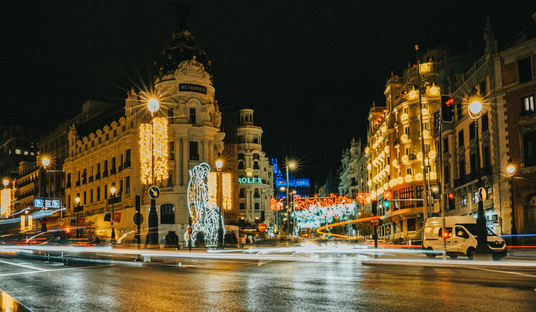
Why does the street look different depending on where you stand?
Gran Vía was built in stages by different developers and architects working to a shared width and alignment but not a single uniform design, so its architectural character shifts noticeably from one end to the other.
Near its eastern start, close to Plaza de Cibeles and the junction with Calle de Alcalá, the buildings tend toward heavier, more classically ornamented facades from the 1910s. Moving west, the architecture becomes progressively more modern in feel, reflecting the later phases of construction through the 1920s, when Art Deco and early modernist influences from the United States and central Europe were more current. This produces one of Madrid’s clearest visible timelines of early 20th-century commercial architecture, laid out along a single walkable line.
Several of the avenue’s individual buildings are notable in their own right as protected structures within Madrid’s heritage listings, including former cinema palaces, department-store buildings and one of the city’s earliest purpose-built office towers, though this article treats the street as a whole rather than any single building on it.
What happened to Gran Vía during the Spanish Civil War?
During the siege of Madrid (1936–1939), Gran Vía was repeatedly hit by artillery fire from Nationalist positions and became known informally as “Avenida de los Obuses” — Howitzer Avenue — a nickname documented in period accounts of the siege.
The street’s height, width and central position made it a prominent target, and photographs and newsreel footage from the period, held in Spanish and international archives, show shelled buildings along its length. This period sits alongside the broader, well-documented history of the siege of the capital, during which the front line ran close to what is now the Casa de Campo and university area to the west of the centre.
Why is Gran Vía sometimes compared to Broadway?
The comparison to Broadway comes from the concentration of theatres and, later, cinemas built along and just off the avenue from the 1910s onward, a pattern that continues today with several working theatres still operating on or near the street.
This theatre district grew up alongside the avenue’s construction rather than before it, since the buildings that now house these venues were themselves part of the new development along the route. The comparison to New York’s theatre district is journalistic shorthand rather than an official designation, and readers should treat it as a description of the street’s function rather than a formal title.
How does Gran Vía fit into Madrid today?
Gran Vía functions as a major commercial and transit corridor, carrying heavy pedestrian and public transport traffic between the Sol/Callao area and Plaza de España, with several metro interchanges along or near its length.
For a visitor working out how the surrounding area fits together, Gran Vía is a useful spine: it runs close to Puerta de Alcalá and Plaza de Cibeles to the east, passes near the Chueca district (home to the Museo del Romanticismo), and ends at Plaza de España to the west. Its own metro station and surrounding stops make it a practical point of reference for orienting a day around central Madrid’s landmarks and museum districts, many of which are catalogued on this site’s landmarks and sights and museums and galleries pages.
As with any historic street still in active use, opening times for individual buildings, theatres or metro services along Gran Vía change; readers should confirm current details directly with Metro de Madrid or the relevant venue before planning a visit around them.
Access Madrid is an independent guide written from published, checkable sources. We have not visited the places described here and we do not publish personal recommendations or invented ‘local favourites’ — where something is singled out as notable, we say who says so. Opening times, fares, closures and prices change at short notice, so treat everything here as a starting point and confirm with the museum, operator or venue directly before building a day around it. We give no advice on visas, insurance, health or safety; use your own government’s official guidance for those.