Cercanías is Madrid’s commuter rail network, operated by Renfe, the Spanish state railway company. It runs on mainline tracks rather than the underground tunnels used by the Metro, which means it moves faster over distance and reaches towns well outside the city that the Metro never touches. It is better than the Metro whenever the journey is long, radial, or involves a station outside the M-30 ring.
What is Cercanías, exactly?
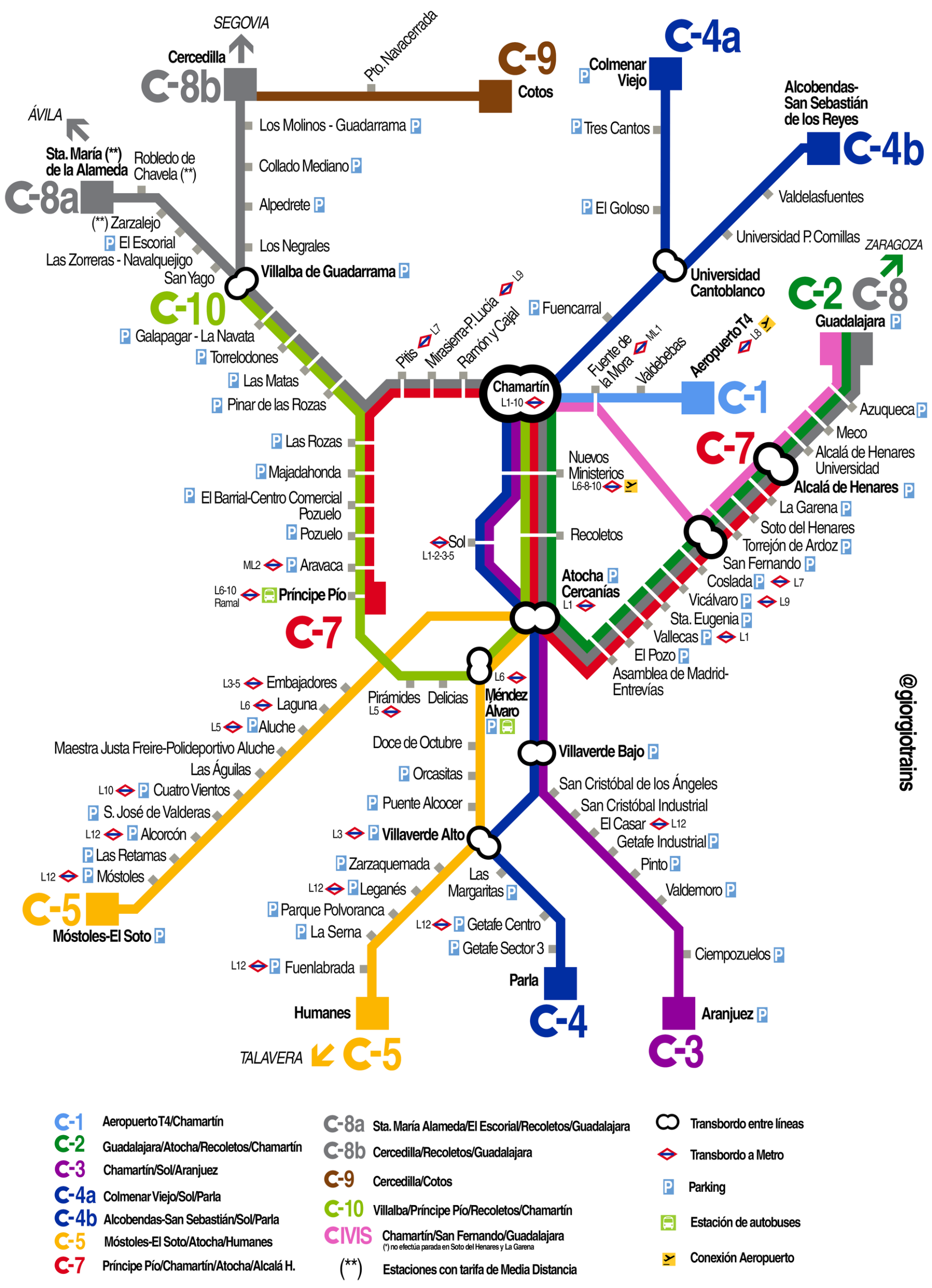
Cercanías Madrid is one of several Cercanías networks Renfe operates in Spanish cities, alongside those in Barcelona, Valencia and elsewhere. It consists of several numbered lines — C1 through C10, though not all numbers are currently in use — that radiate out from central Madrid to surrounding municipalities in the Comunidad de Madrid, and in some cases beyond the region’s border.
Unlike the Metro, which was built specifically as an urban underground system, Cercanías uses existing national rail infrastructure. Trains are larger, run less frequently at busy periods than Metro trains do, and stop at fewer stations along any given stretch — because the point of the network is covering distance, not serving every corner of a neighbourhood.
How is Cercanías different from the Metro?
The Metro is a dense grid designed for short hops within the built-up city; Cercanías is a smaller number of long spokes designed for longer hops between the centre and its periphery. That single difference explains almost everything else about when to use one over the other.
- The Metro has roughly a dozen numbered lines covering the city closely, with stations often a few hundred metres apart.
- Cercanías has around ten lines, with stations that can be several kilometres apart once outside the centre.
- Metro trains run in tunnels almost everywhere; Cercanías trains run largely at surface level or in cuttings, on the same tracks used by regional and long-distance trains.
- Cercanías reaches towns such as Alcalá de Henares, Aranjuez, El Escorial and Alcobendas that sit entirely outside the Metro map.
Both networks converge at a handful of major interchange stations — Atocha, Chamartín, Nuevos Ministerios, Príncipe Pío and Sol among them — which is usually where a journey should switch from one system to the other.
How does the fare system compare with the Metro’s?
Cercanías and Metro fares are coordinated by the Consorcio Regional de Transportes de Madrid (CRTM), the regional transport authority, which structures the whole network — bus, Metro, and Cercanías — around concentric fare zones rather than treating each mode separately. The practical effect is that a single rechargeable card can usually cover both.
The Tarjeta Multi and the Abono Transporte, the region’s travel card and season-ticket products, both work across Cercanías, Metro and city buses within the zone a traveller has paid for. The distinction between the two products — one a pay-as-you-go card, the other a flat-fee period pass — is explained in detail in the guide to the Tarjeta Multi and the Abono Transporte. The Metro’s own zone logic, which Cercanías largely mirrors, is set out in the piece on how the Madrid Metro fare system works.
Fares for Cercanías itself depend on how many zones a journey crosses, and Renfe publishes current prices and route maps on its own site. Because fares and timetables change, always confirm the current figure on Renfe’s official Cercanías pages before travelling.
When is Cercanías actually the better choice?
Cercanías wins whenever a journey is long, radial, or terminates outside the M-30. Three situations come up repeatedly.
Airport transfers. Line C1 runs between the city centre and Adolfo Suárez Madrid–Barajas Airport, calling at Terminal 4. Because the train runs on the surface at speed rather than making the frequent stops a Metro line would, it typically covers the distance faster than the Metro’s own airport line for anyone starting from a station near the centre — Atocha or Chamartín, in particular. Renfe’s site carries the current C1 timetable and the airport supplement, where one applies.
Reaching towns and outer suburbs. Aranjuez, Alcalá de Henares, El Escorial, Getafe and Alcobendas are among the municipalities Cercanías reaches directly. None of these appear on the Metro map at all, because they sit outside Madrid’s municipal boundary. For a resident living in one of these towns and commuting into the centre, Cercanías is not an alternative to the Metro — it is the only rail option.
Crossing the city itself, quickly. Even within Madrid, a Cercanías line can beat the Metro on a long north–south or east–west run, because it makes far fewer stops. A journey from Chamartín in the north to Atocha in the south, for instance, is a handful of minutes by Cercanías rather than a multi-change Metro trip.

Does Cercanías reach the airport, and is it the best route there?
Yes — Line C1 serves Terminal 4 of Adolfo Suárez Madrid–Barajas Airport, in addition to the dedicated Metro line that also reaches the airport (Terminals 1-2-3 and T4). Which is faster depends on where a journey starts: from Atocha or Chamartín, Cercanías is usually direct and quick; from many other points inside the city, the Metro’s own airport line may involve fewer changes. Renfe’s Cercanías site and the Metro operator’s own airport information page are the places to check current routes and any airport supplement before travelling, since surcharges and schedules are adjusted periodically.
Is Cercanías useful for day trips outside the city?
It is the standard way to reach several of the towns most commonly visited from Madrid on a single-day basis, because they sit on Cercanías lines and have no other rail link to the capital. Aranjuez, seat of a former royal residence, and El Escorial, site of the royal monastery, are both reachable directly by Cercanías from central Madrid stations, without needing a car or a long-distance train ticket. Alcalá de Henares, a university town east of the city, is on the same network. In each case the practical shape of the trip — which line, which frequency, roughly how long the ride takes — is published by Renfe and is worth checking on the day, since weekend and holiday timetables can differ from weekday ones.
Is Cercanías useful for someone who actually lives in Madrid?
For a resident, Cercanías tends to matter less for getting around the centre — the Metro is denser and better suited to that — and more for commuting from, or travelling regularly to, anywhere outside the M-30. Someone living in a district on the network’s outer reaches, or in a satellite town, will use Cercanías as their daily commuter line in the way a Londoner might use National Rail rather than the Underground.
It is also worth knowing which central districts have a Cercanías station on their doorstep even though they feel entirely urban. Vallecas, in the city’s south-east, has its own Cercanías stops in addition to Metro coverage. Moncloa-Aravaca, in the north-west, is served by Príncipe Pío, one of the network’s major interchange stations. Understanding how Madrid’s districts and barrios are laid out helps explain why some neighbourhoods lean on Cercanías far more than others.
One further practical case: Atocha, Cercanías’ busiest central station, sits a short walk from the cluster of galleries sometimes called the Golden Triangle of Art — the Prado, the Reina Sofía and the Thyssen-Bornemisza. Arriving by Cercanías from a station further out can be a faster route into that part of the city than changing Metro lines twice.
So which should a traveller default to?
Inside the built-up centre, the Metro’s density usually makes it the simpler choice for short hops between neighbourhoods. Cercanías earns its place the moment a journey stretches beyond that — to the airport, to a station on the city’s edge, or to a town the Metro map does not cover at all. Broader guidance on choosing between Madrid’s transport modes, including buses and the wider rail network, is covered in the Getting Around Madrid section, and background on how the city’s neighbourhoods relate to one another is available in the Neighbourhoods archive.
Access Madrid is an independent guide written from published, checkable sources. We have not visited the places described here and we do not publish personal recommendations or invented ‘local favourites’ — where something is singled out as notable, we say who says so. Opening times, fares, closures and prices change at short notice, so treat everything here as a starting point and confirm with the museum, operator or venue directly before building a day around it. We give no advice on visas, insurance, health or safety; use your own government’s official guidance for those.
Featured image: Photo by Javier Perez Montes, source, CC BY-SA 4.0

Related reading
Madrid Airport to the City Centre: What Each Option Really Costs.